Monday 30 August 2010

Penberi to Abercastle

Stage 17 - 9.5 miles taking 5.5 hrs on August 26th

A chilly pervasive north-easterly wind made this walk more of a challenge, as the path wended its way firstly northwards and then directly into the gale towards the north east. Just behind the 'head' of Carn Penberi on my return to the Coast Path proper I passed the remnants of an old abandoned quarry - the first of numerous ruins which bear witness to the industrial past of this wild part of Pembrokeshire. More of this later.

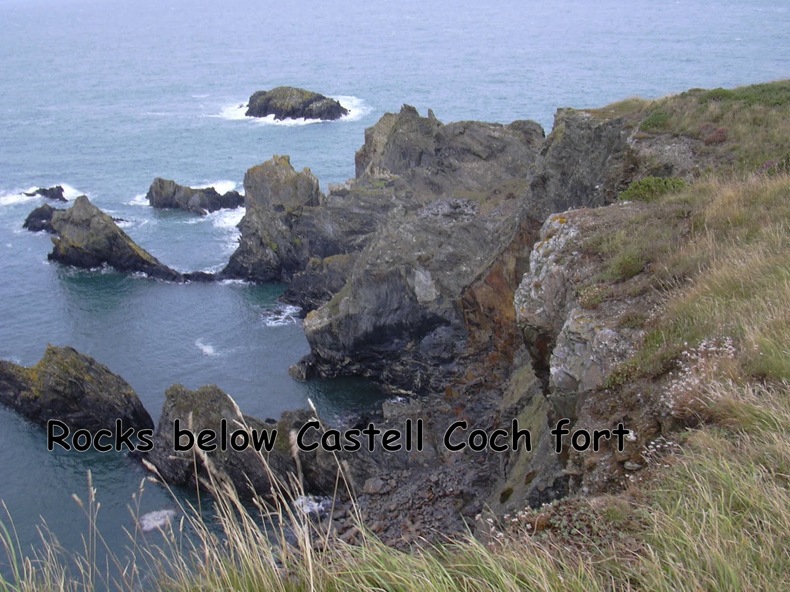
On almost every promontory on this part of the coast (and indeed right round Pembrokeshire) there is a prehistoric fort (most of which I find difficult to identify, because of the vegetation). This section was no exception, boasting no less than two Castell Coch (Red Castles). The first one was reasonably easy to see on approach, based above a spectacular rock formation at Porth Tre-Wen. Not far from here an expedition of about 12 of young people were being led in a line along the path. All stopped to allow me to pass - I felt I should give a salute like HMQ.

At Aber-Pwll the path descended precipitously and at the bottom, instead of the usual limekiln, there was a small oven built into the wall. Nothing in my guidebooks indicates why this should be there - perhaps it had a different use. The tide was right up at this time and so the small beach was not apparent and the place deserted except for a lone guillemot preening itself on a rock. Up above the cove I passed what I thought was a herd of cows but, on closer inspection it was about 40 or more black & white / brown & white (piebald / skewbald if I am being technically correct) ponies.

Abereiddi beach, a little further along, was also empty except for the sea and the car park held only a few cars together with a number of coasteering company mini-buses. At one period Abereiddi was a bustling slate quarrying village but now it is whole-heartedly a tourist destination, with a few jolly, painted cottages.

A sad little line of remnants of workers' cottages (formerly called The Street) leads into a marshy area to the south of Ynys Barry. These were devastated by an inundation early in the 20th century, but the quarry had already been closed in 1901.


The Blue Lagoon is a 'sea quarry', close to the beach - a quarry flooded by the sea. It is now mecca for coasteering daredevils, as well as being a spectacular sight.


While I was there, three separate groups of youngsters, each group wearing different coloured helmets, swam round from some nearby rocks, then across the lagoon and scrambled up to the 'platform' beneath the ruined building. They then took orderly turns to leap the 10 ft or so down into the water. In addition, four older youths were doing their own thing from the higher level - see the pic of one of them in mid-jump (perhaps 20 ft).

After Abereiddy, the path continues round and above the wonderful sandy beach of Traeth Llyfn, scene of many fondly remembered family swimming and bodyboarding expeditions. Today you're not allowed to take a car along the mile of track through what used to be Barry Island farm (but is now a holiday complex) and park close to the beach, so only reasonably energetic walkers can get there, before going down the steep metal steps to its golden beach. I do wonder how often I brought my long-suffering family to the brink of death in their childhood - the beach is said to have very dangerous currents for swimming - but it used to be packed with swimmers of all ages when we were there some 15 years ago. Perhaps the effective closure of the beach has encouraged its present dangerous designation. Ah well.

And so to Porthgain.... home of the Sloop Inn, one of my favourite haunts and the Shed Bistro, which serves unimaginably good shellfish. But today was not about gastronomic experiences or even bucolic lazing about outside the pub: I ate my spartan sandwiches on a stone bench on the quay.

Porthgain has a varied industrial past - slate quarrying, clay digging and brick making - and the many ruins bear witness to this. The path goes past the steep-sided quarry and associated buildings down to the harbour, where the brick hoppers on the quayside are still used for storing fishermen's bits and pieces. At one stage there was a tramway which brought slate from Abereiddi to Porthgain harbour across Ynys Barri (Barry Island - an island really only in the sense of having marshy tracts on two sides between itself and the 'mainland').

Two white beacons stand way above the entrance to Porthgain harbour to guide boats in - in the way described in Swallows and Amazons, if I remember rightly.


Almost continuously from above Porthgain to the next small port, Aber-Draw, a stone wall ran on my right, separating the fields from the cliff edge. In places a mass of lichen and flowers covered it; in others you could see the amazing skill of the builders. In fact the wall continued for much of the way to Abercastle, making it about 4 miles in total.


Aber-draw is the harbour, as they say, for the inland village of Trefin. Above it is a small stone circle (aptly named Swyn-y-don - Charm of the Wave), preceded by a single isolated large standing stone. Down beneath, at the water's edge, the ruins of a grain mill, its millstones decorated by seaweed, tell the story of yet another previously bustling port.


A short diversion from the official path finds Carreg Samson, a gromlech which stands, rather incongruously, in a field of sheep above the village of Abercastle, my destination for this walk.


Then it was off down into the village, passing en route two cannon muzzles which had been up-ended for use as bollards for boats to secure their lines to. Reduce, re-use, recycle.


This had been a walk I shall always remember - full of evidence of a comparatively recently abandoned industrial past mixed in with the mystical, as yet not fully interpreted remains of prehistoric living. On my way I'd seen seals lazing in the shallows of sheer-sided coves, and wondered at the colours and skill of vegetation which clings to the cliffs where the Atlantic winds blast it daily. And, although I've seen so many natural arches since starting out at Amroth, I never fail to gasp when I find another one.


At every turn to look behind me, I could make out the twin 'peaks' of Carn Penberi and Carn Llidi, which define the landscape of Penmaen Dewi (St David's Head).


Total walked: 132.5 out of 186

Wednesday 25 August 2010

Caerfai, Tyddewi to Penberi

Stage 16: 13 miles in about 7 hours (incl. stop for lunch!) on 24th August

The decision to walk so many miles was not from bravado, but from a necessity to fit my destination-planning round the timetables and routes of the small coastal buses which sprint up and down the coastline, making it possible for walkers to access the Coast Path. Having to date used the Coastal Cruiser and Puffin Shuttle, I am now frequenting the Strumble Shuttle which runs from St David's to Fishguard and back, via the coastal road along which I guided the Sinai Cycling Club almost a year ago. The joy of these small buses is that you can hail them or request them to stop wherever takes your fancy on the route. The snag is that they don't run very often. However, any trip likely to be full of incident, as they have to pull in to avoid cars on the often single track lanes. (pic: greentraveller.co.uk)

Caerfai car park was deserted on this exceptionally windy morning.
There was even sea foam on the cliff top path on the way to St Non's. This is reputed to be the birth place of St David, Dewi Sant - Non being his mother. There is a large 1920's house here now, with a small stone chapel close by, dedicated to St Non. This was added by the original owner of the house in 1934 for his wife who had converted to Catholicism and found it irksome to have to travel 16 miles to the nearest church - much easier to ask the priest to come to her. The small chapel is open to the elements and was built from local stone reclaimed from other disused ecclesiastical buildings. Its serenity in a wild landscape appealed to me. Nearby is a well, said to have sprung when St David was born here, and just across the field are the ruins of an ancient chapel dedicated to St Non.

In the relative calm of Porth Clais (a four limekiln harbour, if anyone's keeping a tally), a mile or more further on, all sorts of derring-do was about to happen, as a mini-bus load of youngish people arrived kitted out for coasteering - in jolly coloured jackets and hard hats. On the water, more people were launching kayaks. I felt a little unadventurous as I clambered back on to the clifftop. I watched the coasteerers starting to absail across some sheer cliffs. When I couldn't bear the suspense any longer, I turned for a further battle with the west wind, and rounded the last peninsula of St Bride's Bay before heading for Pembrokeshire's Atlantic coast once more.

All along the Coast Path there are benches at view points, often with an inscribed plaque dedicated to the memory of so-and-so, who loved this spot. Sometimes this individual weary walker thinks that so-and-so could have ventured a little further from the car park - so that the bench was, say, more in the middle of nowhere. The National Coast Path Authority is apparently clamping down now - fewer benches are to be erected and certainly without permission. With this in mind I liked the way someone had put a simply-engraved plaque marked TAID on one of the gates - surprising: Taid is Welsh for grandfather in North Wales. Tad-cu would be the word in Pembrokeshire.

The backdrop scenery after Porth Clais starts to change - lots of boulders and rocky outcrops, reflected out to sea by a number of small islands, with tantalising views of other bigger ones further away.

One of the ragged collection of rocks called Carreg yr Esgob, just outside Porthlysgi, looks as if it is about to break in two. To the south the island of Skomer was still in view, just off the southern tip of St Bride's Bay and I could see 2 tankers over there still waiting their turn to go into Milford.


Photographic ponies on a small patch of grass gave away the fact that I was now on National Trust land again. I think the NT must own just about every scenic headland in this bit of Britain. Perhaps every one.


In front of me was Ramsey Island and its smaller off shore relatives. Between Ramsey and the mainland, Ramsey Sound is an exciting race of water, called colloquially the Bitches, after a rocky point off Ramsey. Facing this, close to the site of an old copper mine at Treginnis, stood a man, clad in waterproofs, with his binoculars trained on the swirling water. I stopped to ask him about the hawk I'd seen hovering and plunging not far away - a kestrel, he told me. His job is observing porpoises - can't be many with his job description - but today's water was going to be too rough to sort out the porpoises from the white horses, so he was happy to give me a brief wildlife advice session. We watched gannets swooping down - apparently these birds follow porpoises, because the cetaceans (showing off now - the word for the sort of creature they are) disturb the same sort of food which the gannets feed on. On Grassholm Island, which I could just make out 8 miles away, there are more than 30,000 pairs of gannets nesting - around 10% of the world population. Gannets nest on only three islands in Britain so, if you see gannets in Cornwall, they come from Grassholm - and will return all the way there after feeding.


At Porthstinian none of the little Ramsey ferries was venturing across the rough water, nor any dare-devil small boats going out over the Bitches. Crossing over the set of cables used for getting supplies to the precipitous Lifeboat Station, the path winds its way round yet another head (Point St John) and into Porth Mawr bay, at last sheltered from the insistent wind.

Ahead rears the landmark of Carn Llidi - not quite a mountain, but just as charasmatic - which I'd seen all the way back from Martin's Haven, across St Bride's Bay. In the shelter of Porth Mawr bay lie two large sandy beaches. At the first, Porthselau, a group of children had built a huge sandcastle - probably about 3ft tall and one boy was being king of it.

By now the path had filled up with walkers and I was having to stop every 100 yards or so to let people past: time for a break at Whitesands beach, in amongst hundreds of beachgoers, surfers, swimmers, dogs and all (mostly out of this picture!).

The surf was magnificent and I could only admire the surfers who could ride the incoming waves for what seemed like an age.


I followed the path away from Whitesands, past an almost deserted beach at Porthmelgan (no toilets or car park), through a boulder-strewn landscape all the way to Penmaen Dewi (St David's Head), which is a rocky headland, giving an opportunity to wave farewell to Ramsey and Skomer beyond, not to mention the smaller islands a little further out called the Bishops and Clerks - a treacherous area for shipping. In 140AD in a survey of the known world the Romans described Penmaen Dewi as the ‘Promontory of the Eight Perils’.

From an earlier period, Coetan Arthur burial chamber is camouflaged amongst the many boulders. Where there are fewer stones, the heather has spread to make deep purple meadows, but it even makes itself at home on the bare rocks.


The path runs along the length of the base of Carn Llidi, and visible up on the peak there were scores of walkers who had made it to the top.


To my left, the angry Atlantic battered itself against the many cliffs and coves, until I turned a corner and found a rather more sheltered seascape.

I was lucky enough to spot two dolphins or porpoises swimming in one of the less frantic bays along this stretch. This more than justified my recent investment in a pair of binoculars.

My next target was away in the distance: Carn Penberi, another stone-helmeted peak, beyond which lay my car. The guidebook remarked what a pity it was that the walker had to climb over the shoulder of Penberi, and it was indeed a bit like climbing a loft ladder in places.

I was just grateful that the way did not insist that I climb over its head.


Total walked: 123 miles out of 186

Friday 20 August 2010

Newgale to Caerfai, Tyddewi

Stage 15: 19th August, approx 9 miles in 4.5 hours.

The path has now crossed an important line: from the English side of the county into the Welsh / Cymraeg. I've now changed onto a new map for North Pembrokeshire, and it is very noticeable on this map that from the north of Newgale (Niwgl) onwards, the majority of names (places, bays, rocks and so on) are Welsh. And so it will continue all the way from now on to Llandudoch (St Dogmaels). Gwych!


The start of the journey from Newgale beach was a switchback - or perhaps more like a bucking bronco trying to rid itself of me like a hapless horsefly - with countless steep ups and downs. The Park Authority has helpfully provided steps on many of the slopes, up which I dutifully toiled. But after a while I found myself using the unofficial 'escape routes' to the side of each set of stairs, as the risers of the steps seemed to get greater and greater.... I felt bad that I was probably adding to the erosion, but I am not a giant, or at least not incredibly fit . Going down again on the other side, I am like Christopher Robin, doing one step at a time.


The coastline on this part of the walk is like the frayed edge of a blanket - all rocky bobbles and ragged threads of rocks reaching out into the sea. Two adjacent peninsulas - Dinas Fach and Dinas Fawr - stick out into the bay. In between them is the National Trust's Pointz Castle - a mediaeval motte - and here there were once again photogenic ponies keeping the grass under control. As I was looking at my map to see how to reach the path to Dinas Fawr, the National Trust pony warden turned up. He had no idea where the path was but we had a good chat about the ponies - he looks after a lot of them for the NT and walks about 10 miles every day to do so.


The path out on to Dinas Fawr was not a lot further on, and I took the diversion out to the end of the point. What an amazing place: the path was very narrow, precarious and rocky. The lichen bore witness to the pureness of the air and the rocks were tipped with white edges. Magical.
I tried not to look down too much. From the end of the promontory I could see back to Newgale and on to Solva. On the skyline to the south east the refinery chimneys of the Milford Haven waterway were still obvious.


And so on to Solva, past St Elvis's Farm where there is a small 'forgotten' chapel / holy place. I couldn't discern where it was - just remembered that it exists because I heard about it through PLANED.
Solva's small harbour is hidden away behind a couple of large headlands and I imagine it can be treacherous to navigate in by boat, but very sheltered once safely inside.
At one time Solva had 12 limekilns, a measure of what an important port it used to be. Now there are 4 left.


Del boy look out - parked on Solva quay, Will the Fish has a vehicle to rival Trotter's Independent Traders. I like the number plate. And I'm very partial to lobster & crab too...


The way from Solva to Caerfai (close to St David's) passed this impressive pre-historic fort at Porth y Rhaw. Quite often I find it difficult to make out the ramparts and other fortifications of the many forts along the coastline, as vegetation has claimed them. But I couldn't miss this one. Just before it, at Aberllong, there were the remains of three tugs which went aground on the rocks as recently as 1986.


Caerfai is a small beach at the foot of high cliffs very close to St David's. It has a wonderful mix of sand, rocks and caves to explore and a very steep path back up to the car park. I watched one dad arrive with a child on his shoulders: child dumped gently on the ground and dad immediately sat down too. Ah, those were the days.


Total walked: 110 out of 186

Tuesday 17 August 2010

St Bride's Haven to Newgale

Stage 14: St Bride's Haven to Newgale - 12 miles taking about 6 hours on 16th August.

A journey through many havens: St Bride's, Mill, Little, Broad, Druidston and Nolton, not to mention the lesser known Madoc's and Davy William's Haven.

The sun was blisteringly hot when the Puffin Shuttle bus left me at St Bride's Haven, having woven its way from Newgale, where I parked the car, through all the villages I planned to walk to. Even though it was only 10 am, the thought of heatstroke did cross my mind as I turned my back on St Bride's Castle and set out northwards. Just to be safe, I unzipped the bottoms of my hiking trousers and faced the world in shorts. Out in the bay six tankers were calmly waiting in the heat haze - presumably the other two I'd seen the day before yesterday had nipped off round St Ann's Head into Milford Haven. Memo to self: must check if the price of oil rose yesterday.

Just before Mill Haven this sculpture lies to one side of the path - one of a series of five by Alain Ayers entitled 'the Eyes of the Sea'.

For the first 2 hours of my walk I saw no-one. As I crossed the wooden bridge at Mill Haven, a small flock of Canada geese floated on the quiet sea. All were pointing in one direction, but when I looked again they'd all turned as one to float the other way. All was surreally quiet except for the odd small fishing boat moving from one location to the next.

Sounds of water ski-ers warned me that I was about to re-enter civilization; then I met three sets of walkers - always a sure sign that a car park is not far away.
At the harbour in Little Haven there were lots of people were doing different things in the water. And many others were having a pint outside the pub on the quay.


It would have been possible to explore the cave at Settlands point at the north tip of Little Haven at low tide, and then carry on across another sandy beach towards Broad Haven. This would have saved me the walk up a 1-in-5 hill and the equally steep descent to Broad Haven on the other side but, right at the start, I promised myself to take no short cuts, so perhaps it was as well the tide was up.


Tourism was booming at Broad Haven - good for Pembrokeshire's economy - but it's not really my thing. I have to confess, though, to wolfing down a Mr Whippy (with flake), before climbing up to the cliff top once again. Here I stopped to talk with a lady from the Midlands and the discussion turned to Photoshop - as you do when the small talk is about the weather, the crowds and so on. She had created a series of photos of her grandson as a pixie by adding dragonfly wings. By the time I moved on, I'd convinced her that she should write a story with her grandson as pixie-hero. Yep, really.

About 1/2 mile further on, there were two cyclists inching their way down the narrow stony track and I did an uncharacteristic thing: I told them that they shouldn't really be there. I can only assume I was having a guilt-ridden (no pun, of course) moment.

At Haroldston Chins there were two other cyclists canoodling on the bench but, as the path there is tarmacced and close to the road, I kept quiet. Close by is a plaque dedicated to the memory of Paul Blick, one of the founders of the path. I owe him a lot of sweat and enjoyment.

Many of the cliffs on this journey were covered in vegetation: grass, bracken, and so on, but in other places there were signs of landslips. The beaches at both Druidston and Nolton Havens were busy as I passed by.
Between the two are the arches at Madoc's Haven - they look like caves in my picture, but the clarity of the water gives away the view at low tide.

Ricket's Head, a vast crumbling rock marks the southern extremity of Newgale Sands.


Just before Newgale Beach, which is two miles of sand backed by a pebble bank, there is a hollow with a brick chimney and spoil heaps of coal - the relics of Trefrane colliery, and a reminder of the mining industry which thrived a hundred years ago in this area. There are seams of coal in many of the cliffs I passed today.

At Newgale there's yet another limekiln - every port locally seems to have had one.


Total walked: 101 miles of 186