Friday 30 July 2010

Angle to Hundleton


Walk 8 - approx 8.5 miles (+ a detour)

The most noticeable thing about this walk was the background noise. I've got used to the sound of waves smashing rocks, birds screaming and whistling, even the guns of Castlemartin. Usually however there has been general all-round silence on my trip so far. This walk along the Milford Haven waterway (River Cleddau) was anything but silent. The Chevron refinery vibrated metallically; on the river there were continuous loud sounds of whatever is done when oil is unloaded from a tanker into a pipeline; eventually I neared the construction site for the Power Station and heard intermittent sounds of metal hitting metal and general clattering. One of my guide books suggests missing the river walks out, but this would be missing a vital part of Pembrokeshire (and a large chunk of the overall total mileage). The jetties, refineries, chimneys, gas tanks and different sorts of tankers do not add up to a glamorous sight, but they are an integral part of the county and bring great wealth to Pembrokeshire.

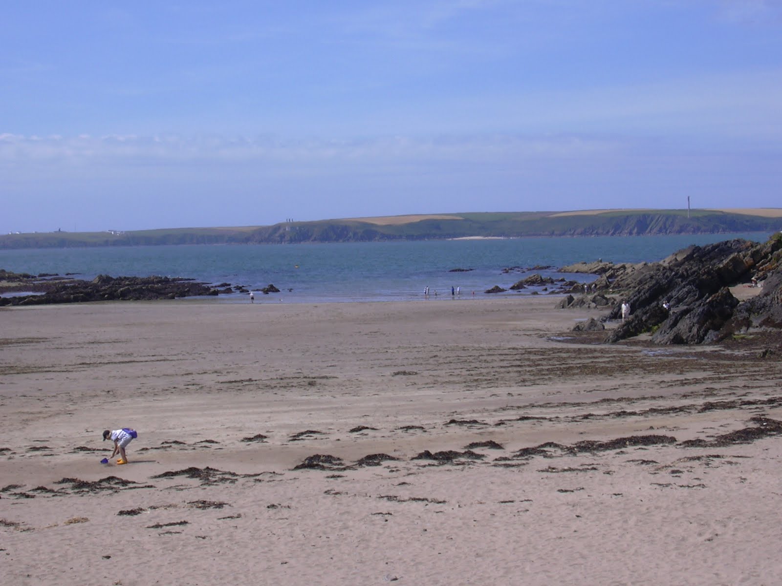
Having convinced myself thus, I set off from East Angle bay in the direction of Hundleton, a small village about 2 miles from Pembroke. Scattered across the first bit of beach I crossed were lots of bits of bricks, a legacy from the Angle brickworks. The path followed the river shore through a number of fields, some recently silaged, another with barley ripening nicely in the sun. All the time I was heading towards the vast refinery chimneys and other buildings.

Between the refinery and the river stands yet another Victorian military fort, Popton, restored in the 20thC by BP, who owned it at the time. (It is at the far right of the pic.) Now it's the property of Chevron. Most of the fortifications dotted along the river and coast in this area were built when Britain was almost paranoid about the danger of a French invasion. By the time the string of forts, turrets, look out posts and so on were complete, history had moved on, and many were scarcely used. Some were adapted during the First World War, but generally they are a rather endearing, if not very pretty, anachronism.

It seemed to take forever to get round the refinery site. I played a game of tortoise and hares with two girls who are also walking the whole path. Together we had to cross a field of Friesian heifers with their attendant Limousin bull. I was very happy to leave that field.

At Pwllcrochan (where I saw these rather diseased looking bulrushes), my two companions jumped ship, as it were, into a car and I went on alone only to find that the path ahead was closed. I plodded off along the road on the recommended detour. The reason for the diversion, which seemed to take forever, became plain - the construction site of the new Pembroke Power station. I passed countless entrances to the site on my trudge along this undulating road and arrived in Hundleton with a few minutes to spare before the Coastal Cruiser bus would whisk me back to Angle.

For the second time on my coastal journey one of my Welsh learners appeared from across the road, opposite the bus stop - this one a day-course attendee, who I've only met twice. Clearly I can't expect to go round Pembrokeshire incognito.

Walked so far: 50.5 miles

You can find more information about the military history of Pembrokeshire on:
http://www.experiencepembrokeshire.com/history-archaeology/military-heritage

Wednesday 28 July 2010

Freshwater West to Angle village

Walk 7 - about 8.5 miles, taking 4 hours.


This was not a walk for vertigo sufferers. It started peacefully enough in brilliant sunshine with an amble across wonderful Freshwater West beach, where I met one of my Narberth students (Welsh learner), who was watching her children have surfing lessons. Ahead of me I could see a procession of walkers starting up the hillside on to the cliffs - the numbers indicating that the holiday season has started. I joined them, and soon found that the path became steep and steeper.

From the past I could hear in my brain the voice of Chaim, an Israeli guide on the Mencap Cycle Ride across the Sinai Desert, saying 'There are no uphills, only downhills'. He was lying. And today the downhills were every bit as challenging as the uphills on the other side. I would not dream of taking a mountain bike down any one of them. The National Park sign rather belatedly called my attention to the matter.


The limestone cliffs of the previous bits of coastline had been replaced by sandstone - a sumptuous red colour, which is found in many of the pebbles and rocks strewn on Freshwater West beach and in all the coves I passed on the way to Angle. The cliffs were often stripy and many appeared to have folds and pleats.
Out on the blue, blue sea I could see the pilot boat flirting with a huge tanker, which finally left the Milford Haven waterway and turned for the Atlantic. On its way into port was the Irish Ferry (Isle of Inishmore), racing for Pembroke Dock, no quarter given. Small yachts were enjoying the breeze and over ahead was St Ann's Head.

It was quite nice once the boom-boom of the Castlemartin range guns gave way to the usual sea noises. All was at peace in my world, with birdsong and many different coloured butterflies and the rasping of my breath at each summit. Eventually the path became more gentle and I passed Sheep and Rat Islands on my way round to West Angle Bay. Scattered along the coast here are various military buildings. The one I coveted was built right into the westernmost point of the headland. It had a semicircular front, so that a good lookout could be kept at this strategic site.


Over on the other side of the waterway lies St Ann's Head, with its white lighthouse and other buildings, all looking perfect today. Now that I've walked this route, I realise more than ever the scale of the devastation following the Sea Empress's wreck off St Ann's in 1996, and also of course what the Gulf of Mexico is currently suffering.


It was almost time to leave the Atlantic / Irish Sea and start the walk inland along the Waterway to the Cleddau Bridge. First of all though I dropped down into West Angle Bay where the great British seaside holiday was in full swing, with ice creams, sand-sandwiches and wind shelters. The sea had gone way, way out.

I sat for a while on the sea wall and ate three rather stale Welsh cakes which I'd found in my freezer. They probably gave me enough calories to sustain me for the next three days. Then it was off on the next leg, from West Angle Bay round to East Angle Bay. The erosion of the sandstone is quite obvious: it doesn't do to be too close to the edge just here.


The first bit of fortification to pass is Thorn Island, now a grand hotel for very loud screaming seagulls. Next, out in the river is another circular fort on Stack Rock, its shape echoed by the gas terminals at South Hook on the other bank. On my side next was Chapel Bay Fort, lovingly restored complete with big guns by a private individual.


I neared the end of my walk at East Angle Bay and looked across to the refinery, where the flare I saw from Castlemartin range was still bright in the sky.

Total I've walked: 42 miles / 144 still to do.

Sunday 25 July 2010

St Govan's Head to Freshwater West

Day 6 - about 9 miles, probably more.

The army don't practise firing their guns at weekends so it was possible to enter Castlemartin Range East yesterday. The track across the range is made for military vehicles, but the lovely graded stones on it don't make for comfortable walking. So time after time I found myself distracted from the recommended path and walking along well trodden small paths closer to the cliff edges. If I hadn't done so I never would have seen the many fissures, blowholes, holes and arches which form an amazing sight on this part of the coastline as I wandered around every little headland en route. The army have waymarked the path every 100 yards with a danger sign (see pic - this one a bit wobbly and spattered with pellet holes), so that I could see where the route was supposed to be going and touch base with it every so often. However, I obeyed orders as far as not touching military litter, and gave something metallic and unidentified in the grass a wide berth.


I suppose that even out here big brother needs to keep an eye on us all.


The route went past the Huntsman's Leap (130ft deep), where a huntsman escaping his creditors jumped across (as you do). He later returned to the spot to see what his horse had leapt and dropped dead of fright.


Out to sea Lundy Island, off the North Devon coast, miraged back and forth into view and away to my right a flare at one of the oil refineries reminded me of how close I was to Milford Haven.

If the last walk featured blowholes, this was the day of the arch - although there were plenty of blowholes too. The arches are chronologically next in line after the blowholes. The sea forms the latter by wearing away a cavern in a limestone cliff and being blown upwards until a hole is worn away. (We're not talking days, years here - probably millennia). Arches are formed similarly. Here are some I saw:


The last one is the big daddy of them all: the Green Bridge of Wales.

The final bit of sea-sculptures before stone is turned to sand are the 'stacks' - the stumps which are left once arches have fallen in. The most famous ones are the Elegug Rocks (Stack Rocks). Elegug comes from Heligog - guillemot in Welsh - and in the spring the rocks are covered with these nesting seabirds.


It was a pity that I had to leave all this magnificent geology. The West part of Castlemartin rangeis closed most of the time as the Army can't guarantee the public's safety, so at this point I turned inland and trudged along a rather boring road in the drizzle.

The noise of tanks made me lift my head: there were lots of them in desert camouflage and men scrambling over them. I reached for my camera and then thought better of it: if people have their cameras impounded for photographing the Houses of Parliament, what might happen to me?

On my way to Freshwater West beach I passed through the village of Warren, admired the restored church spire and found an AA sign.


Last year two lots of film crews descended on Freshwater West bay (latest Harry Potter film & Robin Hood). But now it is back to normality with kite flyers and surfers. In the distance I could see Sheep Island, almost at the southern tip of the entrance to the Milford Haven waterway. That's where I am headed for my next walk. Further away still is Skokholm Island, which I sailed around on the Waverley Paddlesteamer about a month ago.

Thursday 22 July 2010

Freshwater East to St Govan's Chapel


Walk no: 5 (I've got to stop calling them 'legs', it's too close to the mark) - about 7 miles. This was the walk to prove the weathermen wrong in their persistent dismal forecasts, but I think we'll call it a draw. I started out in the rain from Freshwater East, not cats and dogs, but definitely wet. As it was before 7 in the morning (how obsessive is that?), I was the only person on the beach and indeed it was about an hour and a half before I saw anyone else. After a while I gave up on my rainjacket; it was more like a black bin bag with sleeves and I was wetter on the inside with sweat than I was on the out. The bracken either side of the path in places made me realise how the Corsa feels in the automatic car wash, but eventually I arrived on open land and dried out a bit. I could see blue skies ahead of me to the west - it had to be better over there.

At Stackpole Quay I could see lights on in the cafe, but everything looked deserted - that's the trouble with setting off so early.


After Barafundle beach, which was deserted except for an early morning jogger and me, I made my way round Stackpole Head and across National Trust land, called Stackpole Warren. There are ponies grazing here - quite a number of them and foals. The National Trust is experimenting I believe with using ponies as part of their conservation plans. I hope they don't get on to the acres of ragwort I saw as well - very poisonous for horses. I am not a ragwort fan; it reminds me of many long hours spent in the sun on the farm pulling the stuff.


Today was the day of the blowhole. I saw four on my route, at least. A blowhole is a hole in the ground through which you can often see the sea beneath. The cliffs, fissures and caves I could see from the path were quite amazing. And the various rock formations just blow your mind away. These arches are to the west of Barafundle.

At Raming Hole, a very steep sided cove the noise from the sea birds was deafening - not gulls, some other birds with a loud, musical call. I saw a lot of different birds today, starting with gulls trying to frighten off a shag, which was drying its wings quite oblivious to the shemozzle of noise. Then there were goldfinches, chough, ravens (I think) and all manner of other birds which are as yet strangers to me.

I found a healthy crop of mushrooms up there too. I could hear my father's voice telling me never NEVER to eat fungus found out in the wild, but I did anyway. Then it was down on to Broadhaven (South) beach, which again was empty save for one man and his dog. By now I had beaten the weatherman, and the sun was shining.

Looking back at Church Rock from Broadhaven you get your last view of Caldey Island and St Margarets in the far distance. From Broadhaven it is a short walk across to St Govan's head and I was lucky that the path across this part of Castlemartin firing range was open. The army are also doing their bit in the conservation of the area, but it somehow seems rather organised with signs warning you not to stray off the path and any number of bunkers (?gun emplacements) in gullies along the way. I could hear the boom-boom of guns in the distance and indeed the red flag was up at St Govan's head, preventing me going on to Stack Rocks had I wanted to.


Instead I went down to St Govan's chapel, squeezed between the cliffs, down steep steps. I felt perhaps I should be going back up them on my knees as pilgrims do en route to Santiago de Compostela. But I didn't want to get my trousers wet again. As my guide book puts it - one thing is demonstrated: monastic life did not encourage obesity.

Then it was on to the Coastal Cruiser bus and a quick whizz back to Freshwater East, squeezing past a surprising number of lorries coming the other way, including one delivering Felinfoel Ales.

Total walked on the path: 25 miles+

Sunday 18 July 2010

Manorbier to Freshwater East


Walk no. 4 - approx 3.5 miles. Bob joined me for this one again and I was in better spirits than a week ago. We left Manorbier and its vast castle behind and walked resolutely past the enigmatically named Dak - which is actually a dreary holiday home split into two - and its wonderful enormous phormiums (a bit like yukkas without the tree trunk) which are in full flower. A steep climb got us to the top of East Moor Cliff and a panoramic view over towards Stackpole and beyond to St Govan's Head, where I will be turning away from the south of the county for the first time.

I decided that today was the day I should take pictures of the many wild flowers and so I dallied along the way, taking pics in the vain hope I might be able to identify them at my leisure. I have memories of a former boss, Leslie Kenton, taking spectacular photos of flowers, so close-up that I felt embarrassed at her intrusion into their private lives. All those bits of plants I learnt in O Level Bilge, sepals, anthers, ovules, stigmas and whatnot, on display for all and sundry to gawp at. However, the flowers I recorded have no need to cover their faces - my camera doesn't do them justice. And identification is going to be a long process.

Before long Bob and I were peering down on Swanlake Bay and some rather disgusting looking patches of seaweed being buffeted about on the waves. At shore level the sea was much more attractive and we wandered on to the beach to look longingly at the mounds of driftwood which we knew we couldn't to collect. I got quite excited by the mammoth leg bone - see pic


- but on closer inspection it was just an ordinary bit of wood. Next, I tried to record the crashing surf on my phone but it sounds like the bath swooshing. I will have to get closer another time.

All the way along the path we met other walkers, from what seemed to be the length and breadth of the UK and beyond. One lady we chatted to for a long while lived in Cumbria. She was moonlighting from a stint of house-sitting for her sister in the Midlands, and had been bribed to go away for the weekend by a party-loving nephew. We all have our different reasons for being out on the path.


The hillside above the dunes at Freshwater East - called the Burrows - is dotted with small shack-like buildings which were put up in the 1930 as holiday homes. When I first arrived in Pembrokeshire some 30 years ago, they really were (mostly very dilapidated) shacks but many have been considerably renovated, or rebuilt in the recent past and are greatly sought after.


So now I have done 10 percent of the walk. Looking forward to the next 90 - or around 168 miles.


Thursday 15 July 2010

Valleyfield Top to Manorbier


Leg 3 - just a bit more than 5 miles, taking the cumulative total I've walked to more than 15 miles. Only another 170 to go.


It was blowing a gale in the sunshine this morning as I started off across Penally range. The spray from the sea a couple of hundred feet down was rising above the cliff tops and I felt it on my face. I felt a bit wimpish as the path occasionally meandered between two lots of gorse or bracken and I got some shelter from the blast.


The tide was up at Lydstep beach and I did my Canute thing for a short while before thinking better of it and retreating into the holiday park, clutching a lost buoy which I then stuffed into my back pack. The holiday park is vast and full of identical chalets, each with its decking and neat plant pot, with solar light. But the feeling there was distinctly like the Prisoner; a self-contained village with no sense of a world outside. Anyway, I wasn't Number 6 today and managed to escape up to Lydstep head, where once again Caldey Island seemed close enough to touch.

The walking now became more up and down, and I looked down on several small coves with near-vertical steps to reach them tempting me. But the weather looked as if it was closing in and my legs warned me against such diversion. At the top of Skrinkle bay I met a father and daughter who had just climbed up. Together we watched a seal swimming just outside the cove.

Just past here the path has to go inland to bypass the Manorbier army camp and I had to trudge round the perimeter of it. Near the end of the compound was a missile pointing towards the west. I don't suppose it was an Exocet - it looked very out of place. All morning I had been watching first a helicopter buzzing me and then various aircraft out to sea (actually it might have been the same plane going round in circles). At one stage a plane dropped a shower of bright flares into the sea.

From around here I had my first view of the refineries and industrial sites on the Milford Haven waterway, rather fuzzy in the distance. Then it was mostly down hill all the way round the Priest's Nose (and past the Parson's Piece) and a final drop down into Manorbier bay. Over in the distance was the castle I had passed first thing in the morning on my way to catch the bus and in the water were a few surfers, left over from the scores who had been there on the high tide.

I haven't quite got the hang of putting pictures on this blog yet and all these are in reverse order.